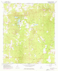
1968 Map of Puckett NW
USGS Topo · Published 1976About this map
Sherwood Forest and the recreational waters of Robinhood Lake define the northern portion of this Rankin County landscape as it appeared in the late 1960s. The area is characterized by a dense network of rural infrastructure, where numerous country churches and family burial grounds reflect a well-established community fabric. Significant local landmarks such as Pearlie Grove Ch and Hebron Hill Cem are situated amidst the winding drainages of Tumbaloo Creek and Richland Creek. Photogrammetric updates from 1975 reveal the gradual expansion of residential footprints and utility corridors, including a prominent Pipeline cutting through the terrain. The presence of both the Old Mt Zion Cem and Mt Zion Ch suggests the migration of local congregations over time, providing valuable geographic markers for genealogists and local historians tracing family lineages in this part of Mississippi.
Find a feature on this map
22 named features on this map. Tap any name to fly to it.
Don’t see what you’re looking for? This feature index may not catch every label — zoom into the map to look around manually.
Map Details
Editions of this 1968 Puckett NW Map
3 editions found
Other maps of this area

1903 · Jackson
USGS Topo · 1:125,000

1905 · Jackson
USGS Topo · 1:48,000

1906 · Florence
USGS Topo · 1:62,500

1908 · Jackson
USGS Topo · 1:62,500

1908 · Florence
USGS Topo · 1:62,500

1922 · Pelahatchee
USGS Topo · 1:48,000

1924 · Pelahatchee
USGS Topo · 1:62,500

1950 · Pelahatchie
USGS Topo · 1:62,500

1952 · Pelahatchie
USGS Topo · 1:62,500

1953 · Meridian
USGS Topo · 1:250,000