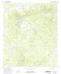
1968 Map of Puckett NW
USGS Topo · Published 1992About this map
Sherwood Forest and the recreational waters of Robinhood Lake represent the mid-century development of eastern Rankin County during the late 1960s. This landscape is defined by the winding drainages of Tumbaloo Creek and Richland Creek, where the terrain begins to rise toward prominent elevations like Coon Hill. The area retains a strong rural character, evidenced by the numerous country churches and family burial grounds that anchor the local community.
Find a feature on this map
19 named features on this map. Tap any name to fly to it.
Don’t see what you’re looking for? This feature index may not catch every label — zoom into the map to look around manually.
Map Details
Editions of this 1968 Puckett NW Map
3 editions found
Other maps of this area

1903 · Jackson
USGS Topo · 1:125,000

1905 · Jackson
USGS Topo · 1:48,000

1906 · Florence
USGS Topo · 1:62,500

1908 · Jackson
USGS Topo · 1:62,500

1908 · Florence
USGS Topo · 1:62,500

1922 · Pelahatchee
USGS Topo · 1:48,000

1924 · Pelahatchee
USGS Topo · 1:62,500

1950 · Pelahatchie
USGS Topo · 1:62,500

1952 · Pelahatchie
USGS Topo · 1:62,500

1953 · Meridian
USGS Topo · 1:250,000