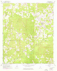
1968 Map of Puckett
USGS Topo · Published 1976About this map
The Strong River winds through the borderlands of Rankin and Simpson counties, defining a landscape of creek bottoms and rural crossroads in the mid-1960s. The town of Puckett serves as a local hub, while the smaller settlement of Everett sits further south near the riverbanks. Remnants of earlier transport and industrial networks are visible in the Old Railroad Grade and a traversing Pipeline, indicating the shifting economic infrastructure of the region.
Find a feature on this map
25 named features on this map. Tap any name to fly to it.
Don’t see what you’re looking for? This feature index may not catch every label — zoom into the map to look around manually.
Map Details
Editions of this 1968 Puckett Map
2 editions found
Other maps of this area

1935 · White Oak
USGS Topo · 1:24,000

1953 · Hattiesburg
USGS Topo · 1:250,000

1953 · Meridian
USGS Topo · 1:250,000

1957 · Meridian
USGS Topo · 1:250,000

1958 · Hattiesburg
USGS Topo · 1:250,000

1965 · Meridian
USGS Topo · 1:250,000
1968 · Puckett NW
USGS Topo · 1:24,000

1968 · White Oak
USGS Topo · 1:24,000
1968 · Puckett
USGS Topo · 1:24,000
1968 · Polkville
USGS Topo · 1:24,000