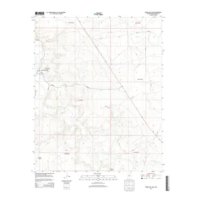
2013 Map of Puerto De Luna
USGS Topo · Published 2013About this map
Puerto De Luna sits at the heart of this high-desert landscape in Guadalupe County, where the valley of the Pecos River creates a corridor of activity amidst the surrounding mesas. The settlement pattern here is tied closely to the river’s path and the local road network, including historic routes like Questa Rd and Potrillo Rd. For those tracing local heritage, the presence of Nuestra Senora De Refugio Cem and isolated ranching outposts like Willis Ranch provides essential geographic anchors. The terrain is marked by significant natural features such as the Cañon de Hughes and the winding Arroyo San Juan de Dios, which dictate the placement of small rural communities like Gerhardt and Monzingo. This survey illustrates the enduring relationship between the river valley and the sparse, cattle-ranching territory of eastern New Mexico.
Find a feature on this map
26 named features on this map. Tap any name to fly to it.
Don’t see what you’re looking for? This feature index may not catch every label — zoom into the map to look around manually.
Map Details
Editions of this 2013 Puerto De Luna Map
This is the sole edition of this map. No revisions or reprints were ever made.
Other maps of this area

1954 · Fort Sumner
USGS Topo · 1:250,000

1958 · Fort Sumner
USGS Topo · 1:250,000

1963 · Santa Rosa
USGS Topo · 1:24,000

1963 · Puerto Creek
USGS Topo · 1:24,000

1963 · Sunshine Mesa
USGS Topo · 1:24,000

1963 · Puerto De Luna
USGS Topo · 1:24,000

1964 · Fallon Ranch
USGS Topo · 1:24,000
1964 · Harben Lake
USGS Topo · 1:24,000

1966 · Gibbons Ranch
USGS Topo · 1:24,000

1966 · Ojo Negro Creek
USGS Topo · 1:24,000