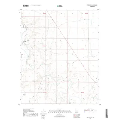
2020 Map of Puerto De Luna
USGS Topo · Published 2020About this map
Puerto De Luna sits at the heart of this Guadalupe County landscape, positioned along the meandering path of the Pecos River. The village layout is defined by historical thoroughfares like Madrid St and Alamo Farm Rd, reflecting a community deeply tied to the fertile river valley. A significant point of interest for genealogists is the Nuestra Señora de Refugio Cem, which serves as a central landmark for local family histories. The surrounding terrain is marked by significant hydrological and topographic features, including the seasonal drainage of Arroyo San Juan de Dios to the east and the deep cuts of Cañon de Hughes to the south. The road network, including Mustang Rd and Paseo Del Sol Rd, illustrates how modern ranching and residential access routes trace the older contours of the New Mexico high plains.
Find a feature on this map
25 named features on this map. Tap any name to fly to it.
Don’t see what you’re looking for? This feature index may not catch every label — zoom into the map to look around manually.
Map Details
Editions of this 2020 Puerto De Luna Map
This is the sole edition of this map. No revisions or reprints were ever made.
Other maps of this area

1954 · Fort Sumner
USGS Topo · 1:250,000

1958 · Fort Sumner
USGS Topo · 1:250,000

1963 · Santa Rosa
USGS Topo · 1:24,000

1963 · Puerto Creek
USGS Topo · 1:24,000

1963 · Sunshine Mesa
USGS Topo · 1:24,000

1963 · Puerto De Luna
USGS Topo · 1:24,000

1964 · Fallon Ranch
USGS Topo · 1:24,000
1964 · Harben Lake
USGS Topo · 1:24,000

1966 · Gibbons Ranch
USGS Topo · 1:24,000

1966 · Ojo Negro Creek
USGS Topo · 1:24,000