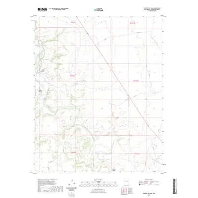
2023 Map of Puerto De Luna
USGS Topo · Published 2023About this map
Puerto de Luna occupies a verdant stretch of the Pecos River valley, serving as a primary point of settlement in this part of Guadalupe County. The landscape is defined by the winding river corridor and the dramatic incision of the Cañon de Hughes to the south. Local heritage is centered around the Nuestra Senora de Refugio Cem, situated near the intersection of Madrid St and the river's edge. This modern survey illustrates how historical land patterns persist through contemporary rural infrastructure, with routes like Alamo Farm Rd and Paseo del Sol Rd following the natural contours of the valley. The arid uplands are cut by seasonal drainages such as the Arroyo San Juan de Dios, creating a stark contrast between the irrigated river bottom and the surrounding high plains.
Find a feature on this map
24 named features on this map. Tap any name to fly to it.
Don’t see what you’re looking for? This feature index may not catch every label — zoom into the map to look around manually.
Map Details
Editions of this 2023 Puerto De Luna Map
This is the sole edition of this map. No revisions or reprints were ever made.
Other maps of this area

1954 · Fort Sumner
USGS Topo · 1:250,000

1958 · Fort Sumner
USGS Topo · 1:250,000

1963 · Santa Rosa
USGS Topo · 1:24,000

1963 · Puerto Creek
USGS Topo · 1:24,000

1963 · Sunshine Mesa
USGS Topo · 1:24,000

1963 · Puerto De Luna
USGS Topo · 1:24,000

1964 · Fallon Ranch
USGS Topo · 1:24,000
1964 · Harben Lake
USGS Topo · 1:24,000

1966 · Gibbons Ranch
USGS Topo · 1:24,000

1966 · Ojo Negro Creek
USGS Topo · 1:24,000