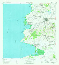
1966 Map of Puerto Real
USGS Topo · Published 1968About this map
The coastal landscapes of southwestern Puerto Rico are anchored by the municipal seat of Cabo Rojo, which sits at the crossroads of the Bajura and Monte Grande regions. This mid-1960s survey reveals a landscape balanced between agricultural traditions and coastal development, featuring the historic Hacienda La Ratina alongside the newer Monte Carlo Air Strip. The western shoreline is deeply indented by the Bahía de Boquerón, where the Balneario Público de Boquerón and the Refugio de Aves de Boquerón reflect early conservation and tourism efforts.
Find a feature on this map
110 named features on this map. Tap any name to fly to it.
Don’t see what you’re looking for? This feature index may not catch every label — zoom into the map to look around manually.
Map Details
Editions of this 1966 Puerto Real Map
3 editions found
Other maps of this area

1935 · Puerto Real
USGS Topo · 1:25,000

1937 · San German
USGS Topo · 1:25,000

1937 · Puerto Real
USGS Topo · 1:25,000

1938 · Parguera
USGS Topo · 1:30,000

1938 · Cabo Rojo
USGS Topo · 1:30,000

1939 · Mayaguez
USGS Topo · 1:30,000

1941 · San German
USGS Topo · 1:30,000

1941 · Puerto Real
USGS Topo · 1:30,000

1941 · Rosario
USGS Topo · 1:30,000

1942 · Rosario
USGS Topo · 1:30,000
Featured Places
- Cabo Rojo, Cabo Rojo
- Reparto Vista Verde, Cabo Rojo
- Villa Tortuga, Cabo Rojo
- Sector Souchet, Cabo Rojo
- El Fuego y Las Piedras, Cabo Rojo