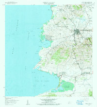
1966 Map of Puerto Real
USGS Topo · Published 1984About this map
The coastal town of Cabo Rojo serves as the hub of this southwest Puerto Rican landscape, where the urban grid of Pueblo Norte and Pueblo Sur meets a network of agricultural and natural landmarks. The map documents a transition in transportation and land use, showing the Via Antigua del Ferrocarril tracing an older economic path through Llanos Tuna. Along the coastline, the maritime character of the region is evident at Puerto Real and the extensive Bahía de Boquerón, which is bordered by the Bosque Estatal de Boquerón. Genealogy and local history researchers will find a dense distribution of rural schools, such as Escuela Garfield and Escuela Ballajá, alongside family-named sites like Isabel Josefa and Hacienda La Ratina, illustrating the social fabric of the barrios before modern expansion.
Find a feature on this map
101 named features on this map. Tap any name to fly to it.
Don’t see what you’re looking for? This feature index may not catch every label — zoom into the map to look around manually.
Map Details
Editions of this 1966 Puerto Real Map
3 editions found
Other maps of this area

1935 · Puerto Real
USGS Topo · 1:25,000

1937 · San German
USGS Topo · 1:25,000

1937 · Puerto Real
USGS Topo · 1:25,000

1938 · Parguera
USGS Topo · 1:30,000

1938 · Cabo Rojo
USGS Topo · 1:30,000

1939 · Mayaguez
USGS Topo · 1:30,000

1941 · San German
USGS Topo · 1:30,000

1941 · Puerto Real
USGS Topo · 1:30,000

1941 · Rosario
USGS Topo · 1:30,000

1942 · Rosario
USGS Topo · 1:30,000
Featured Places
- Cabo Rojo
- Reparto Vista Verde, Cabo Rojo
- Villa Tortuga, Cabo Rojo
- Sector Souchet, Cabo Rojo
- El Fuego y Las Piedras, Cabo Rojo