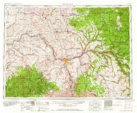
1958 Map of Pullman
USGS Topo · Published 1958About this map
Pullman and Moscow serve as the primary hubs in this mid-century portrait of the Palouse region and the Clearwater Valley. The map captures the intricate relationship between the winding Snake River and the extensive rail networks of the Northern Pacific RR and Union Pacific RR, which facilitated the movement of grain and timber across the Washington and Idaho border. To the east, the landscape rises into the Saint Joe National Forest and the peaks of the Saint Joe Mountains, while the Nez Perce Indian Reservation occupies a significant portion of the southeastern quadrant.
Find a feature on this map
84 named features on this map. Tap any name to fly to it.
Don’t see what you’re looking for? This feature index may not catch every label — zoom into the map to look around manually.
Map Details
Editions of this 1958 Pullman Map
2 editions found

Other maps of this area

1903 · Oakesdale
USGS Topo · 1:125,000

1905 · Oakesdale
USGS Topo · 1:125,000

1910 · Pullman
USGS Topo · 1:125,000

1914 · Avery
USGS Topo · 1:125,000

1917 · Avery
USGS Topo · 1:125,000

1919 · Walla Walla
USGS Topo · 1:125,000

1921 · Walla Walla
USGS Topo · 1:125,000

1923 · Washington Creek
USGS Topo · 1:125,000

1924 · Kamiah
USGS Topo · 1:125,000
1924 · Weippe
USGS Topo · 1:125,000