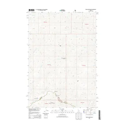
2013 Map of Pungo Mountain
USGS Topo · Published 2013About this map
Grays Peak and Pungo Mtn define the high country of the central Idaho wilderness, where the borders of Boise National Forest and Challis National Forest converge. This area is defined by its drainage systems, with many creeks like Marble Cr and Pungo Cr flowing through steep drainages toward the Middle Fork Salmon River along the southern edge of the sheet. The landscape is largely inaccessible except by air or foot, evidenced by the presence of the Indian Creek USFS Airport and the Pungo Creek Campground. In the lower elevations, the Aquinaldo Flat provides a rare break in the terrain near the junction of Indian Cr and its tributaries, marking a site where the Valley County and Custer County line traverses the wilderness.
Find a feature on this map
36 named features on this map. Tap any name to fly to it.
Don’t see what you’re looking for? This feature index may not catch every label — zoom into the map to look around manually.
Map Details
Editions of this 2013 Pungo Mountain Map
This is the sole edition of this map. No revisions or reprints were ever made.
Other maps of this area

1930 · Casto
USGS Topo · 1:125,000

1957 · Challis
USGS Topo · 1:250,000

1960 · Challis
USGS Topo · 1:250,000

1961 · Greyhound Ridge
USGS Topo · 1:62,500

1962 · Norton Ridge
USGS Topo · 1:24,000

1962 · Shellrock Peak
USGS Topo · 1:24,000

1963 · Challis
USGS Topo · 1:250,000
1963 · Sliderock Ridge
USGS Topo · 1:24,000
1973 · Rainbow Peak
USGS Topo · 1:24,000
1973 · Safety Creek
USGS Topo · 1:24,000