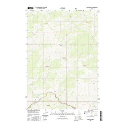
2017 Map of Pungo Mountain
USGS Topo · Published 2017About this map
Middle Fork Salmon River carves through the southern section of this map, marking a deep canyon system where Valley County and Custer County meet. This 2017 edition documents a landscape defined by the overlapping boundaries of the Boise National Forest and Challis National Forest. High points like Pungo Mtn and Grays Peak rise above a dense network of drainages including Middle Fork Indian Cr and Pungo Cr. A rare point of modern access and infrastructure is found at the Indian Creek USFS Airport, situated on a flat above the Indian Creek confluence. The map illustrates the complex topography of central Idaho, from the high alpine ridges to the river-level benches of Aquinaldo Flat, providing a detailed record of the wilderness trails and waterways that have remained largely unchanged for generations.
Find a feature on this map
45 named features on this map. Tap any name to fly to it.
Don’t see what you’re looking for? This feature index may not catch every label — zoom into the map to look around manually.
Map Details
Editions of this 2017 Pungo Mountain Map
This is the sole edition of this map. No revisions or reprints were ever made.
Other maps of this area

1930 · Casto
USGS Topo · 1:125,000

1957 · Challis
USGS Topo · 1:250,000

1960 · Challis
USGS Topo · 1:250,000

1961 · Greyhound Ridge
USGS Topo · 1:62,500

1962 · Norton Ridge
USGS Topo · 1:24,000

1962 · Shellrock Peak
USGS Topo · 1:24,000

1963 · Challis
USGS Topo · 1:250,000
1963 · Sliderock Ridge
USGS Topo · 1:24,000
1973 · Rainbow Peak
USGS Topo · 1:24,000
1973 · Safety Creek
USGS Topo · 1:24,000