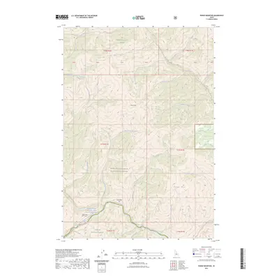
2023 Map of Pungo Mountain
USGS Topo · Published 2023About this map
Indian Creek USFS Airport serves as a remote hub for backcountry access in this protected wilderness area. Situated at the convergence of several major drainages, including Indian Creek and the Middle Fork Salmon River, the terrain is defined by steep ridges and narrow valleys. This map illustrates the intersection of several managed lands, primarily the Frank Church-River of No Return Wilderness and portions of both the Boise National Forest and Challis National Forest. High-elevation points like Grays Peak and Pungo Mtn overlook a network of pack trails, such as the Middle Fork Trl and Marble Creek Trl, which provide the only overland navigation through these steep slopes. The inclusion of indigenous naming, such as Wongopaampeteka'a Naokwaide, alongside traditional mining-era labels like Placer Creek, reflects a complex layering of human history within the central Idaho mountains.
Find a feature on this map
39 named features on this map. Tap any name to fly to it.
Don’t see what you’re looking for? This feature index may not catch every label — zoom into the map to look around manually.
Map Details
Editions of this 2023 Pungo Mountain Map
This is the sole edition of this map. No revisions or reprints were ever made.
Other maps of this area

1930 · Casto
USGS Topo · 1:125,000

1957 · Challis
USGS Topo · 1:250,000

1960 · Challis
USGS Topo · 1:250,000

1961 · Greyhound Ridge
USGS Topo · 1:62,500

1962 · Norton Ridge
USGS Topo · 1:24,000

1962 · Shellrock Peak
USGS Topo · 1:24,000

1963 · Challis
USGS Topo · 1:250,000
1963 · Sliderock Ridge
USGS Topo · 1:24,000
1973 · Rainbow Peak
USGS Topo · 1:24,000
1973 · Safety Creek
USGS Topo · 1:24,000