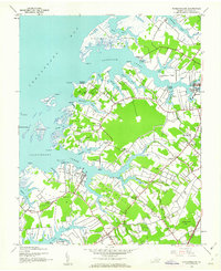
1943 Map of Pungoteague
USGS Topo · Published 1962About this map
The complex shoreline of the Chesapeake Bay dominates this mid-century survey of Accomack County, where a network of tidal creeks like Pungoteague Creek and Onancock Creek separate finger-like peninsulas such as Matchotank Neck and Yeo Neck. This maritime landscape is defined by its working waterfront, evidenced by Finneys Wharf, Evans Wharf, and Boggs Wharf serving the small coastal communities. Further inland, the Pennsylvania railroad line provides a terrestrial corridor for transit, cutting through a rural interior dotted with local centers like Pungoteague and Savageville. Genealogists will find a wealth of community landmarks, including St George Ch, Evergreen Ch, and the Cashville Sch, alongside distinct family-named areas like Crockett Town and Smithville. The presence of a dedicated Landing Strip near the Killmontown Area reflects early 1940s infrastructure amidst the traditional farming and fishing geography of Virginia's Eastern Shore.
Find a feature on this map
79 named features on this map. Tap any name to fly to it.
Don’t see what you’re looking for? This feature index may not catch every label — zoom into the map to look around manually.
Map Details
Editions of this 1943 Pungoteague Map
2 editions found
Other maps of this area

1903 · Crisfield
USGS Topo · 1:62,500

1920 · Crisfield
USGS Topo · 1:62,500

1931 · Accomac
USGS Topo · 1:48,000

1935 · Accomac
USGS Topo · 1:62,500

1942 · Chesconessex
USGS Topo · 1:31,680

1942 · Nandua Creek
USGS Topo · 1:24,000

1942 · Tangier Island
USGS Topo · 1:24,000

1942 · Parksley
USGS Topo · 1:24,000

1943 · Jamesville
USGS Topo · 1:31,680

1943 · Pungoteague
USGS Topo · 1:31,680