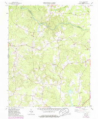
1963 Map of Purdy
USGS Topo · Published 1986About this map
The Nottoway River forms a winding natural boundary between Sussex and Greensville Counties, anchoring a landscape of extensive swamp systems and agricultural settlements. This 1963 survey, updated in the 1980s, reveals a rural economy organized around the Norfolk and Western railway, which passes through the village of Purdy. The area is characterized by several small crossroads communities such as Fields Crossroads and Cowie Corner, which served as local hubs for the surrounding farmsteads.
Find a feature on this map
31 named features on this map. Tap any name to fly to it.
Don’t see what you’re looking for? This feature index may not catch every label — zoom into the map to look around manually.
Map Details
Editions of this 1963 Purdy Map
3 editions found
Other maps of this area

1919 · Jarratt
USGS Topo · 1:62,500

1919 · Mc Kenney
USGS Topo · 1:48,000

1919 · Emporia
USGS Topo · 1:62,500

1919 · Arringdale
USGS Topo · 1:48,000

1920 · Arringdale
USGS Topo · 1:62,500

1921 · Mc Kenney
USGS Topo · 1:62,500

1942 · Arringdale
USGS Topo · 1:62,500

1942 · Emporia
USGS Topo · 1:62,500

1943 · Mc Kenney
USGS Topo · 1:62,500

1951 · Jarratt
USGS Topo · 1:62,500