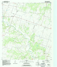
1995 Map of Purmela
USGS Topo · Published 1995About this map
Cowhouse Creek winds through the central corridor of this Coryell County landscape, carving a wide valley between the uplands of the Edwards Plateau. The rural community of Purmela and nearby South Purmela serve as the primary focal points of settlement in the northwest, while the small hamlet of Arnett is situated further east. This 1995 map captures a region defined by ranching and small-scale industry, evidenced by scattered corrals and a Gravel Pit located near the southern bend of the creek. Genealogists will find interest in several family-named landmarks and burial sites, including Smith Cem and King Cem near the southern settlement of King. In the southeast, the topography becomes more pronounced with the presence of Culp Mountain, McCluskey Mountain, and Bagget Mountain, providing a clear look at the local elevation changes that dictate the flow of smaller tributaries like Bee Creek and Honey Creek.
Find a feature on this map
21 named features on this map. Tap any name to fly to it.
Don’t see what you’re looking for? This feature index may not catch every label — zoom into the map to look around manually.
Map Details
Editions of this 1995 Purmela Map
This is the sole edition of this map. No revisions or reprints were ever made.
Other maps of this area

1887 · Lampasas
USGS Topo · 1:125,000

1888 · Hamilton
USGS Topo · 1:125,000

1888 · Meridian
USGS Topo · 1:125,000

1894 · Hamilton
USGS Topo · 1:125,000

1894 · Meridian
USGS Topo · 1:125,000

1894 · Lampasas
USGS Topo · 1:125,000

1894 · Gatesville
USGS Topo · 1:125,000

1947 · Purmela
USGS Topo · 1:62,500

1947 · Gatesville West
USGS Topo · 1:24,000

1947 · Pidcoke
USGS Topo · 1:24,000