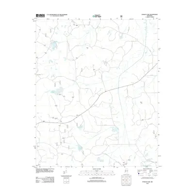
2012 Map of Puskus Lake
USGS Topo · Published 2012About this map
Puskus Lake and the winding course of Puskus Cr dominate this rural landscape in Lafayette County during the early 21st century. The map details a quiet, well-watered territory defined by several small reservoirs and natural basins, including North Cypress Lake, Cypress Lake, and the LT-14a-4 Reservoir. The area is sparsely settled, with small communities like Keel, Burt, and Cambridge connected by a network of county roads. For those tracing family histories or early burial sites, the map is particularly valuable for its precise location of multiple rural cemeteries. These include Smith Cem in the north, Shiloh Cem and Liberty Cem near the central creeks, and both Jefferson Cem and Liberty Hill Cem further south. The convergence of W Cypress Cr and E Cypress Cr south of Rook Hill illustrates the complex drainage patterns that shaped the local topography.
Find a feature on this map
45 named features on this map. Tap any name to fly to it.
Don’t see what you’re looking for? This feature index may not catch every label — zoom into the map to look around manually.
Map Details
Editions of this 2012 Puskus Lake Map
This is the sole edition of this map. No revisions or reprints were ever made.
Other maps of this area

1942 · Denmark
USGS Topo · 1:62,500

1943 · Denmark
USGS Topo · 1:62,500

1944 · Potts Camp
USGS Topo · 1:62,500

1945 · Potts Camp
USGS Topo · 1:62,500

1949 · New Albany
USGS Topo · 1:62,500

1951 · New Albany
USGS Topo · 1:62,500

1955 · Blue Mountain
USGS Topo · 1:62,500

1956 · Tupelo
USGS Topo · 1:250,000

1958 · Tupelo
USGS Topo · 1:250,000
1980 · Thaxton
USGS Topo · 1:24,000