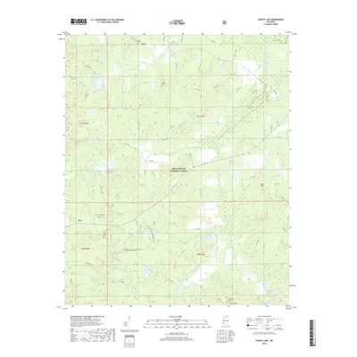
2018 Map of Puskus Lake
USGS Topo · Published 2018About this map
Holly Springs National Forest covers much of this North Mississippi landscape, where the headwaters of the Little Tallahatchie River system define the topography. Small communities such as Keel, Burt, and Liberty Hill are connected by a network of county roads including Co RD 244 and Liberty Hill Rd. For genealogists, the map identifies several historic burial sites, including Jefferson Cem, Smith Cem, and Pine Grove Cem, often situated near local landmarks like Shiloh Ch. The hydrology is dominated by numerous water bodies and drainages, notably Puskus Lake and the various branches of Cypress Creek, such as North Cypress Lake and East Cypress Lake. These features, alongside the N Cypress Non Motorized Tr, suggest a rural environment focused on conservation and forestry management during the early 21st century.
Find a feature on this map
55 named features on this map. Tap any name to fly to it.
Don’t see what you’re looking for? This feature index may not catch every label — zoom into the map to look around manually.
Map Details
Editions of this 2018 Puskus Lake Map
This is the sole edition of this map. No revisions or reprints were ever made.
Other maps of this area

1942 · Denmark
USGS Topo · 1:62,500

1943 · Denmark
USGS Topo · 1:62,500

1944 · Potts Camp
USGS Topo · 1:62,500

1945 · Potts Camp
USGS Topo · 1:62,500

1949 · New Albany
USGS Topo · 1:62,500

1951 · New Albany
USGS Topo · 1:62,500

1955 · Blue Mountain
USGS Topo · 1:62,500

1956 · Tupelo
USGS Topo · 1:250,000

1958 · Tupelo
USGS Topo · 1:250,000
1980 · Thaxton
USGS Topo · 1:24,000