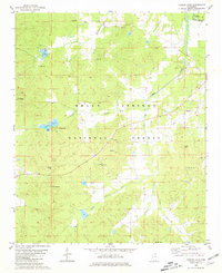
1980 Map of Puskus Lake
USGS Topo · Published 1981About this map
The Holly Springs National Forest dominates this northern Mississippi landscape, where the dense timber is bisected by numerous small drainages and isolated rural settlements. Small communities like Cambridge, Burt, and Keel are tied together by a network of unimproved roads and light-duty trails that navigate the undulating terrain of the Lafayette Co and Marshall Co line. Water resources are central to the area's development, featuring Puskus Lake with its dedicated Recreation Area and Boat Ramp, alongside the upper reaches of Cypress Creek and Wolf Creek. Genealogy and local history are particularly well-represented here through a dense concentration of rural landmarks, including Bethlehem Ch, Union Hill Ch Cem, and Shiloh Cem. These sites, along with several scattered sandpits, reflect an economy rooted in forestry, small-scale extraction, and long-standing community centers.
Find a feature on this map
40 named features on this map. Tap any name to fly to it.
Don’t see what you’re looking for? This feature index may not catch every label — zoom into the map to look around manually.
Map Details
Editions of this 1980 Puskus Lake Map
This is the sole edition of this map. No revisions or reprints were ever made.
Other maps of this area

1942 · Denmark
USGS Topo · 1:62,500

1943 · Denmark
USGS Topo · 1:62,500

1944 · Potts Camp
USGS Topo · 1:62,500

1945 · Potts Camp
USGS Topo · 1:62,500

1949 · New Albany
USGS Topo · 1:62,500

1951 · New Albany
USGS Topo · 1:62,500

1955 · Blue Mountain
USGS Topo · 1:62,500

1956 · Tupelo
USGS Topo · 1:250,000

1958 · Tupelo
USGS Topo · 1:250,000
1980 · Thaxton
USGS Topo · 1:24,000