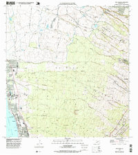
1992 Map of Puu O Kali
USGS Topo · Published 1999About this map
Waiohuli-Keokea (Kihei) Homesteads and numerous other agricultural subdivisions define the land use patterns on the western slopes of Maui's high volcanic terrain. This 1992 compilation reveals an intricate network of irrigation, featuring the Haiku Ditch, Lowrie Ditch, and Kalialinui Ditch, which manage water flow across the arid coastal plains. The landscape is deeply incised by numerous gulches such as Pulehu Gulch and Kaonoulu Gulch, flowing toward the Pacific Ocean. On the shoreline, Kalama Park and Cove Park offer a contrast to the upland homesteads like Omaoplo Homesteads. Significant local landmarks include Puu o Kali and the Wailuku Makawao Cemetery, marking the boundary between the Wailuku District and Makawao District.
Find a feature on this map
65 named features on this map. Tap any name to fly to it.
Don’t see what you’re looking for? This feature index may not catch every label — zoom into the map to look around manually.
Map Details
Editions of this 1992 Puu O Kali Map
This is the sole edition of this map. No revisions or reprints were ever made.
Other maps of this area

1954 · Maui
USGS Topo · 1:250,000

1954 · Maalaea
USGS Topo · 1:24,000

1954 · Paia
USGS Topo · 1:24,000

1954 · Puu O Kali
USGS Topo · 1:24,000

1954 · Makena
USGS Topo · 1:24,000

1955 · Wailuku
USGS Topo · 1:24,000

1957 · Kilohana
USGS Topo · 1:24,000

1957 · Haiku
USGS Topo · 1:24,000

1957 · Lualailua Hills
USGS Topo · 1:24,000

1966 · Maui
USGS Topo · 1:250,000