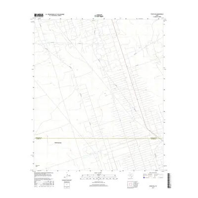
2016 Map of Pyote NE
USGS Topo · Published 2016About this map
The arid landscape of West Texas is defined by a rigorous grid of service roads and intermittent water features north of Monahans. This 2016 survey highlights the geometric development of the Permian Basin, where long stretches of county roads like Co Rd 209 and Co Rd 401 intersect the open plains. The political geography is clearly marked by the boundary line between Winkler Co and Ward Co, cutting horizontally across the terrain. A significant natural landmark, Monument Draw, trends through the southern portion of the map, providing a glimpse into the local hydrography. The road network, including Ranch Rd 1219, serves the industry and sparse settlements of this high-desert region.
Find a feature on this map
11 named features on this map. Tap any name to fly to it.
Don’t see what you’re looking for? This feature index may not catch every label — zoom into the map to look around manually.
Map Details
Editions of this 2016 Pyote NE Map
This is the sole edition of this map. No revisions or reprints were ever made.
Other maps of this area

1954 · Pecos
USGS Topo · 1:250,000

1957 · Pecos
USGS Topo · 1:250,000

1968 · Wink South
USGS Topo · 1:24,000

1968 · China Ranch
USGS Topo · 1:24,000

1969 · Pyote NE
USGS Topo · 1:24,000

1969 · Pyote East
USGS Topo · 1:24,000

1969 · Monahans
USGS Topo · 1:24,000
1969 · Pyote West
USGS Topo · 1:24,000

1970 · Wink North
USGS Topo · 1:24,000

1970 · Kermit
USGS Topo · 1:24,000