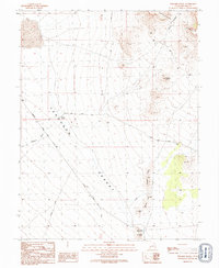
1991 Map of Pyramid Knoll
USGS Topo · Published 1991About this map
Ferguson Desert and the high ridges of the Confusion Range define this high-altitude landscape in western Millard County. The map details a remote desert environment where water sources and livestock management are the primary markers of human presence. Isolated features such as Probst Pond and the Probst Corral suggest the area's importance for local ranching, while Ecks Knoll Reservoir sits at the southern edge of the quadrangle near Ecks Knoll.
Find a feature on this map
13 named features on this map. Tap any name to fly to it.
Don’t see what you’re looking for? This feature index may not catch every label — zoom into the map to look around manually.
Map Details
Editions of this 1991 Pyramid Knoll Map
This is the sole edition of this map. No revisions or reprints were ever made.
Other maps of this area

1908 · Fish Springs
USGS Topo · 1:250,000

1910 · Fish Springs
USGS Topo · 1:250,000

1953 · Richfield
USGS Topo · 1:250,000

1953 · Delta
USGS Topo · 1:250,000

1958 · Richfield
USGS Topo · 1:250,000

1958 · Delta
USGS Topo · 1:250,000

1960 · Conger Range
USGS Topo · 1:62,500

1960 · Burbank Hills
USGS Topo · 1:62,500

1960 · Crystal Peak
USGS Topo · 1:62,500

1960 · Conger Mountain
USGS Topo · 1:62,500