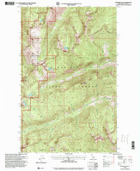
1996 Map of Pyramid Peak
USGS Topo · Published 2000About this map
Pyramid Peak and the high ridges of the Selkirk Crest dominate this portion of the Idaho panhandle during the mid-1990s. The landscape is defined by its dramatic verticality, where prominent summits like Parker Peak, Fisher Peak, and Russell Mountain look down upon a network of high-elevation basins. These basins contain numerous alpine waters, including Big Fisher Lake, Parker Lake, and the clustered Ball Lakes, which feed a system of drainage creeks such as Trout Creek and Spanish Creek.
Find a feature on this map
27 named features on this map. Tap any name to fly to it.
Don’t see what you’re looking for? This feature index may not catch every label — zoom into the map to look around manually.
Map Details
Editions of this 1996 Pyramid Peak Map
This is the sole edition of this map. No revisions or reprints were ever made.
Other maps of this area

1911 · Priest Lake
USGS Topo · 1:250,000

1913 · Priest Lake
USGS Topo · 1:250,000

1958 · Sandpoint
USGS Topo · 1:250,000

1963 · Sandpoint
USGS Topo · 1:250,000

1965 · Farnham Peak
USGS Topo · 1:24,000

1965 · Moravia
USGS Topo · 1:24,000

1965 · Copeland
USGS Topo · 1:24,000

1967 · The Wigwams
USGS Topo · 1:24,000
1967 · Roman Nose
USGS Topo · 1:24,000

1968 · Smith Falls
USGS Topo · 1:24,000