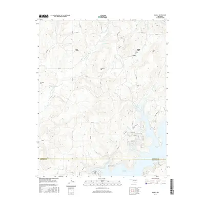
2016 Map of Qualls
USGS Topo · Published 2016About this map
The rugged Ozark foothills of the Cherokee and Sequoyah county line are defined by the expansive waters of Tenkiller Ferry Lake and the smaller Tenkiller Lake. This landscape is marked by prominent peaks such as Grapevine Mtn, Sellers Mtn, and Round Top Mtn, which overlook several small rural settlements. In the northern reaches, the community of Qualls sits near the headwaters of White Oak Br, while the resort village of Paradise Hill occupies the southern shoreline near Sawmill Hollow. Local family history is preserved at sites like White Oak Cem, Sellers Cem, and Phillipps Cem. The terrain is deeply incised by drainages such as Greenleaf Creek and Linder Bend Cr, illustrating the complex topography that surrounds these reservoir communities. This map provides a detailed view of the road networks connecting these upland settlements to the lakefront developments.
Find a feature on this map
65 named features on this map. Tap any name to fly to it.
Don’t see what you’re looking for? This feature index may not catch every label — zoom into the map to look around manually.
Map Details
Editions of this 2016 Qualls Map
This is the sole edition of this map. No revisions or reprints were ever made.
Other maps of this area

1898 · Tahlequah
USGS Topo · 1:125,000

1901 · Muscogee
USGS Topo · 1:125,000

1901 · Tahlequah
USGS Topo · 1:125,000

1905 · Muscogee
USGS Topo · 1:125,000

1905 · Tahlequah
USGS Topo · 1:125,000

1946 · Fort Smith
USGS Topo · 1:250,000

1948 · Hulbert
USGS Topo · 1:62,500

1948 · Webbers Falls
USGS Topo · 1:62,500

1950 · Hulbert
USGS Topo · 1:62,500

1950 · Webbers Falls
USGS Topo · 1:62,500