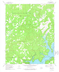
1974 Map of Qualls
USGS Topo · Published 1978About this map
Tenkiller Ferry Lake dominates the southeastern corner of this landscape, its waters filling the Illinois River valley and creating a jagged shoreline of inlets and points. The 1970s terrain is heavily defined by conservation and military use, with the Gruber State Game Management Area and Cookson Refuge preserving the wooded uplands of Grapevine Mountain and Sellers Mountain. Small rural settlements like Qualls and White Oak are tucked away near the northern boundary, while family-named landmarks such as Sellers Cem and Philipps Cem indicate the area's deep-rooted homestead history.
Find a feature on this map
28 named features on this map. Tap any name to fly to it.
Don’t see what you’re looking for? This feature index may not catch every label — zoom into the map to look around manually.
Map Details
Editions of this 1974 Qualls Map
This is the sole edition of this map. No revisions or reprints were ever made.
Other maps of this area

1898 · Tahlequah
USGS Topo · 1:125,000

1901 · Muscogee
USGS Topo · 1:125,000

1901 · Tahlequah
USGS Topo · 1:125,000

1905 · Muscogee
USGS Topo · 1:125,000

1905 · Tahlequah
USGS Topo · 1:125,000

1946 · Fort Smith
USGS Topo · 1:250,000

1948 · Hulbert
USGS Topo · 1:62,500

1948 · Webbers Falls
USGS Topo · 1:62,500

1950 · Hulbert
USGS Topo · 1:62,500

1950 · Webbers Falls
USGS Topo · 1:62,500