
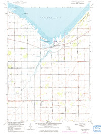
1963 Map of Quanicassee
USGS Topo · Published 1964About this map
The southern shoreline of Saginaw Bay defines this landscape where the Quanicassee River empties into the marshy coastal flats. In the early 1960s, the small settlement of Quanicassee served as a focal point for the surrounding agricultural townships of Hampton, Wisner, Merritt, and Gilford. The map reveals a highly engineered drainage system essential for farming the low-lying terrain, featuring names like Nearing Drain, Russell Drain, and Hawkins Drain.
Find a feature on this map
38 named features on this map. Tap any name to fly to it.
Don’t see what you’re looking for? This feature index may not catch every label — zoom into the map to look around manually.
Map Details
Editions of this 1963 Quanicassee Map
2 editions found
Other maps of this area

1916 · Bay City
USGS Topo · 1:62,500

1919 · Bay City
USGS Topo · 1:62,500

1919 · Saginaw
USGS Topo · 1:62,500

1941 · Saginaw
USGS Topo · 1:62,500

1943 · Bay City
USGS Topo · 1:62,500

1943 · Saginaw
USGS Topo · 1:62,500

1954 · Flint
USGS Topo · 1:250,000

1958 · Flint
USGS Topo · 1:250,000

1963 · Fish Point
USGS Topo · 1:24,000

1963 · Fairgrove
USGS Topo · 1:24,000