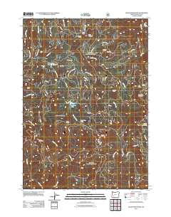
2011 Map of Quartz Mountain
USGS Topo · Published 2011About this map
Limpy Prairie and the surrounding highlands of the Umpqua National Forest dominate this 2011 survey, revealing a landscape defined by its remote water features and mountain meadows. High-elevation drainage basins feed multiple cataracts, including Yakso Falls, Hemlock Falls, and Clover Falls, which descend toward the Little River. The map highlights several small, isolated bodies of water such as Lake in the Woods, Hemlock Lake, and the curiously named Dead Cow Lake.
Find a feature on this map
54 named features on this map. Tap any name to fly to it.
Don’t see what you’re looking for? This feature index may not catch every label — zoom into the map to look around manually.
Map Details
Editions of this 2011 Quartz Mountain Map
This is the sole edition of this map. No revisions or reprints were ever made.
Other maps of this area

1955 · Quartz Mtn
USGS Topo · 1:62,500

1955 · Red Butte
USGS Topo · 1:62,500

1955 · Mace Mtn
USGS Topo · 1:62,500

1955 · Illahee Rock
USGS Topo · 1:62,500

1958 · Roseburg
USGS Topo · 1:250,000

1959 · Roseburg
USGS Topo · 1:250,000

1978 · Diamond Lake
USGS Topo · 1:100,000
1989 · Acker Rock
USGS Topo · 1:24,000
1989 · Taft Mountain
USGS Topo · 1:24,000
1989 · Twin Lakes Mountain
USGS Topo · 1:24,000