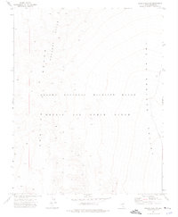
1973 Map of Quartz Peak NW
USGS Topo · Published 1976About this map
Nellis Air Force Range and the Desert National Wildlife Range share this high-desert landscape in Lincoln County, Nevada. The overlapping boundaries of these federal lands create a restricted territory where military airspace and conservation efforts converge across the stark terrain of the Spotted Range. To the east, the broad expanse of Indian Springs Valley provides a dramatic shift in elevation, while the evocative Fallout Hills rise to the northwest. This 1973 survey, photogrammetrically mapped from 1972 aerial photography, documents the topography of a region primarily defined by its remoteness and strategic importance for both national defense and wildlife preservation, showing the intersection of range management and military operations in the Great Basin.
Find a feature on this map
6 named features on this map. Tap any name to fly to it.
Don’t see what you’re looking for? This feature index may not catch every label — zoom into the map to look around manually.
Map Details
Editions of this 1973 Quartz Peak NW Map
2 editions found
Other maps of this area

1907 · Las Vegas
USGS Topo · 1:250,000

1908 · Las Vegas
USGS Topo · 1:250,000

1942 · Emigrant Valley
USGS Topo · 1:125,000

1942 · Indian Spring
USGS Topo · 1:125,000

1952 · Papoose Lake
USGS Topo · 1:62,500
1952 · Frenchman Lake
USGS Topo · 1:62,500

1954 · Caliente
USGS Topo · 1:250,000

1954 · Las Vegas
USGS Topo · 1:250,000

1957 · Las Vegas
USGS Topo · 1:250,000

1959 · Caliente
USGS Topo · 1:250,000