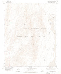
1973 Map of Quartz Peak SW
USGS Topo · Published 1976About this map
The Spotted Range dominates this 1970s landscape, serving as a prominent topographical spine between high-altitude basins in Southern Nevada. This survey illustrates a complex intersection of land management and restricted access, where the Desert National Wildlife Range overlaps with the high-security boundaries of the Nellis Air Force Range. To the east, the terrain descends into the broad expanse of Indian Springs Valley, a region defined by its wide alluvial floors. The map also records the Lincoln Co Clark Co boundary line, tracing the political division across the high ridges and desert flats during a period when this area remained a strictly controlled military and conservation corridor.
Find a feature on this map
5 named features on this map. Tap any name to fly to it.
Don’t see what you’re looking for? This feature index may not catch every label — zoom into the map to look around manually.
Map Details
Editions of this 1973 Quartz Peak SW Map
2 editions found
Other maps of this area

1907 · Las Vegas
USGS Topo · 1:250,000

1908 · Las Vegas
USGS Topo · 1:250,000

1942 · Indian Spring
USGS Topo · 1:125,000

1952 · Mercury
USGS Topo · 1:62,500
1952 · Frenchman Lake
USGS Topo · 1:62,500

1954 · Las Vegas
USGS Topo · 1:250,000

1957 · Las Vegas
USGS Topo · 1:250,000

1959 · Las Vegas
USGS Topo · 1:250,000

1962 · Las Vegas
USGS Topo · 1:250,000
1973 · Heavens Well
USGS Topo · 1:24,000