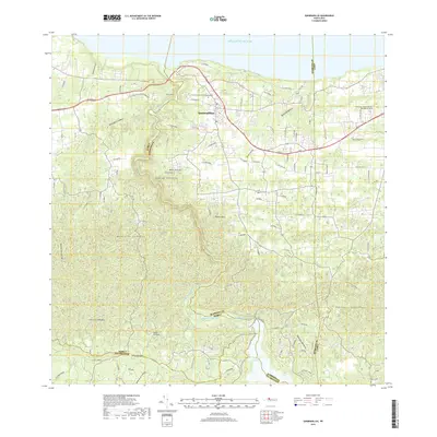
2018 Map of Quebradillas
USGS Topo · Published 2018About this map
Quebradillas sits as the primary hub along the northern coast of Puerto Rico, overlooking the Atlantic Ocean. The landscape transitions from the coastal cliffs and the deep valley of the Rio Guajataca to the rising elevations of the Montanas Aymamon and Montanas Guarionex. This modern survey records the dense road network branching from the Ave Militar and PR-2, linking established neighborhoods like El Centro and the village of Puerto Rico. Genealogy researchers will find the Cementerio Municipal de Quebradillas and the Cementerio Municipal El Remanso de Paz clearly marked, alongside the intricate water management system defined by the Canal Principal de Diversion and the expansive Lago de Guajataca in the southern sector. Named peaks such as Monte Iguina and Monte de la Luz punctuate the limestone topography, illustrating the physical barriers that shaped local settlement patterns.
Find a feature on this map
34 named features on this map. Tap any name to fly to it.
Don’t see what you’re looking for? This feature index may not catch every label — zoom into the map to look around manually.
Map Details
Editions of this 2018 Quebradillas Map
This is the sole edition of this map. No revisions or reprints were ever made.
Other maps of this area

1937 · Moca
USGS Topo · 1:20,000

1938 · Alto Sano
USGS Topo · 1:20,000

1938 · Camuy
USGS Topo · 1:20,000

1938 · San Sebastian
USGS Topo · 1:20,000

1938 · Quebradillas
USGS Topo · 1:20,000

1941 · Moca
USGS Topo · 1:30,000

1941 · Isabela
USGS Topo · 1:30,000

1941 · San Sebastian
USGS Topo · 1:30,000

1942 · Moca
USGS Topo · 1:30,000

1942 · Central La Plata
USGS Topo · 1:30,000
Featured Places
- Quebradillas
- Urbanización Vista al Calvario, Camuy
- Brisas de la Sabana, Camuy
- Hacienda La Sabana, Camuy
- Reparto Apolonio Vélez Ramos, Isabela