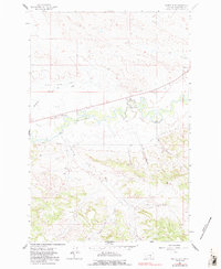
1962 Map of Queens Point
USGS Topo · Published 1991About this map
Melstone serves as the primary settlement in this part of Musselshell County, positioned where the railroad corridor meets the winding path of the Musselshell River. The landscape is defined by an extensive network of water management features, including the Delphia Melstone Canal, the Delphia Melstone Ditch, and the Chandler Ditch, which underscore the region's reliance on irrigation for agriculture.
Find a feature on this map
20 named features on this map. Tap any name to fly to it.
Don’t see what you’re looking for? This feature index may not catch every label — zoom into the map to look around manually.
Map Details
Editions of this 1962 Queens Point Map
2 editions found
Other maps of this area

1954 · Forsyth
USGS Topo · 1:250,000

1954 · Roundup
USGS Topo · 1:250,000

1957 · Forsyth
USGS Topo · 1:250,000

1958 · Roundup
USGS Topo · 1:250,000

1958 · Forsyth
USGS Topo · 1:250,000

1962 · Queens Point
USGS Topo · 1:24,000

1962 · Melstone NE
USGS Topo · 1:24,000

1962 · Melstone NW
USGS Topo · 1:24,000

1963 · Melstone
USGS Topo · 1:24,000

1963 · Musselshell
USGS Topo · 1:24,000