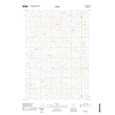
2020 Map of Quietus
USGS Topo · Published 2020About this map
Quietus sits along the Big Horn and Powder River County line, serving as a focal point in a landscape defined by an intricate network of drainage draws and isolated springs. The terrain is marked by prominent landmarks such as The Pyramid, which rises above the surrounding valleys of Canyon Spring Draw and Stagmire Draw. This high-plains geography dictated a sparse settlement pattern, with life centered around reliable water sources like Mud Springs and Sun Spring.
Find a feature on this map
39 named features on this map. Tap any name to fly to it.
Don’t see what you’re looking for? This feature index may not catch every label — zoom into the map to look around manually.
Map Details
Editions of this 2020 Quietus Map
This is the sole edition of this map. No revisions or reprints were ever made.
Other maps of this area

1954 · Hardin
USGS Topo · 1:250,000

1955 · Sheridan
USGS Topo · 1:250,000

1957 · Hardin
USGS Topo · 1:250,000

1958 · Hardin
USGS Topo · 1:250,000

1958 · Sheridan
USGS Topo · 1:250,000

1962 · Sheridan
USGS Topo · 1:250,000
1971 · Roundup Draw
USGS Topo · 1:24,000

1971 · Cabin Creek NW
USGS Topo · 1:24,000
1971 · Box Elder Draw
USGS Topo · 1:24,000
1972 · Stroud Creek
USGS Topo · 1:24,000