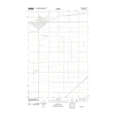
2011 Map of Quincy
USGS Topo · Published 2011About this map
Quincy dominates the northern portion of this Columbia Basin landscape, showing the organized grid and expansion of this Grant County hub as it appeared in the early 2010s. The town’s layout is defined by major thoroughfares such as Central Ave N, Division St E, and A St SE, while the agricultural character of the surrounding terrain is dictated by the massive irrigation infrastructure of the West Canal. This canal snakes through the northwest and central areas, providing the lifeblood for the geometric patchwork of farms and orchards that surround the municipality. To the south and east, the map details the transition from urban streets to a sprawling network of numbered rural roads, including Adams Rd N and Road 5 NW. Significant community landmarks like the Quincy Municipal Airport and the Quincy Golf Course illustrate the specialized land use in this high-desert agricultural region.
Find a feature on this map
66 named features on this map. Tap any name to fly to it.
Don’t see what you’re looking for? This feature index may not catch every label — zoom into the map to look around manually.
Map Details
Editions of this 2011 Quincy Map
This is the sole edition of this map. No revisions or reprints were ever made.
Other maps of this area

1909 · Quincy
USGS Topo · 1:62,500

1910 · Quincy
USGS Topo · 1:62,500

1910 · Winchester
USGS Topo · 1:62,500

1953 · Ritzville
USGS Topo · 1:250,000

1956 · Ephrata
USGS Topo · 1:62,500

1956 · Ephrata SW
USGS Topo · 1:24,000

1959 · Ritzville
USGS Topo · 1:250,000

1965 · Ritzville
USGS Topo · 1:250,000
1966 · Winchester
USGS Topo · 1:24,000
1966 · Monument Hill
USGS Topo · 1:24,000