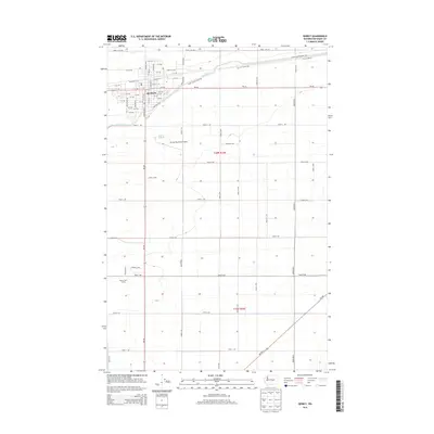
2014 Map of Quincy
USGS Topo · Published 2014About this map
The agricultural and transit hub of Quincy dominates this 2014 survey, illustrating a landscape defined by highly structured irrigation and a geometric road grid. The presence of the West Canal and the associated Canal Maintenance Rd highlights the engineering required to sustain this region's productivity. The settlement itself is shown in detail, including the central business district and residential streets such as Division St W and Marginal Way. Beyond the town center, the map reveals key infrastructure like the Quincy Municipal Airport and recreational spaces including the Quincy Golf Course. The surrounding terrain in Grant County is marked by a precise network of named secondary roads, from Road 11 NW to Road 3 NW, which facilitate movement across the agricultural allotments of t20n r24e and t19n r24e.
Find a feature on this map
40 named features on this map. Tap any name to fly to it.
Don’t see what you’re looking for? This feature index may not catch every label — zoom into the map to look around manually.
Map Details
Editions of this 2014 Quincy Map
This is the sole edition of this map. No revisions or reprints were ever made.
Other maps of this area

1909 · Quincy
USGS Topo · 1:62,500

1910 · Quincy
USGS Topo · 1:62,500

1910 · Winchester
USGS Topo · 1:62,500

1953 · Ritzville
USGS Topo · 1:250,000

1956 · Ephrata
USGS Topo · 1:62,500

1956 · Ephrata SW
USGS Topo · 1:24,000

1959 · Ritzville
USGS Topo · 1:250,000

1965 · Ritzville
USGS Topo · 1:250,000
1966 · Winchester
USGS Topo · 1:24,000
1966 · Monument Hill
USGS Topo · 1:24,000