1980 Map of Quincy
USGS Topo · Published 1982About this map
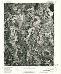
Bentonville and the surrounding Hickory County landscape are captured in this 1980 orthophotoquad, which uses rectified aerial imagery to show the actual ground cover of the era. The terrain is characterized by a complex mix of wooded draws and cleared agricultural plots, revealing the rural land-use patterns of central Missouri just as the Harry S Truman Reservoir was impacting the local hydrology. In the southern portion of the map, the small settlement of Quincy appears as a cluster of structures at a local road junction. The photographic nature of this survey allows for the identification of specific farmsteads and field boundaries that standard topographic maps might generalize, providing a clear record of the area's transition during the early 1980s.
Find a feature on this map
3 named features on this map. Tap any name to fly to it.
Don’t see what you’re looking for? This feature index may not catch every label — zoom into the map to look around manually.
Map Details
Editions of this 1980 Quincy Map
This is the sole edition of this map. No revisions or reprints were ever made.
Other maps of this area

1884 · Bolivar
USGS Topo · 1:125,000

1886 · Stockton
USGS Topo · 1:125,000

1887 · Clinton
USGS Topo · 1:125,000

1887 · Warsaw
USGS Topo · 1:125,000

1892 · Bolivar
USGS Topo · 1:125,000

1894 · Warsaw
USGS Topo · 1:125,000

1894 · Clinton
USGS Topo · 1:125,000

1935 · Dell
USGS Topo · 1:24,000

1940 · Weaubleau
USGS Topo · 1:24,000
1940 · Iconium
USGS Topo · 1:24,000