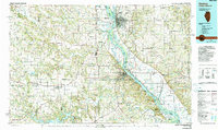
1986 Map of Quincy
USGS Topo · Published 1990About this map
The Mississippi River defines the border between Illinois and Missouri in this mid-1980s regional overview, centering on the city of Quincy and its neighboring river town Hannibal. The landscape is a study in water management and transportation, featuring the Lock and Dam No 21 and the Clarence Cannon Dam, which creates the expansive Mark Twain Lake to the southwest. Educational institutions like Quincy College and Culver-Stockton Col appear alongside an intricate network of rail lines, including the Burlington Northern RR. Beyond the river valley, the terrain is dotted with small rural settlements like Palmyra, New London, and Monroe City, each connected by a grid of state and federal highways. Local heritage is preserved in numerous named cemeteries such as Greenmount Cemetery and Liberty Cemetery, while conservation efforts are evident at the Wakonda State Park and several wildlife areas.
Find a feature on this map
229 named features on this map. Tap any name to fly to it.
Don’t see what you’re looking for? This feature index may not catch every label — zoom into the map to look around manually.
Map Details
Editions of this 1986 Quincy Map
2 editions found
Other maps of this area

1890 · Louisiana
USGS Topo · 1:125,000

1890 · Mexico
USGS Topo · 1:125,000

1890 · Moberly
USGS Topo · 1:125,000

1903 · Kahoka
USGS Topo · 1:125,000

1903 · Palmyra
USGS Topo · 1:125,000

1903 · Edina
USGS Topo · 1:125,000

1925 · Quincy
USGS Topo · 1:62,500

1925 · Liberty
USGS Topo · 1:62,500

1926 · Pittsfield
USGS Topo · 1:62,500

1926 · Mt Sterling
USGS Topo · 1:62,500