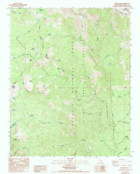
1988 Map of Quinn Peak
USGS Topo · Published 1994About this map
Great Western Divide defines the high-altitude landscape of this Tulare County region, where the boundaries of Sequoia National Park and Sequoia National Forest converge. The terrain is a network of alpine basins and granite ridges, home to clusters of high-country water bodies like Blossom Lakes, Maggie Lakes, and Twin Lakes. The drainage systems of the Little Kern River and the South Fork Kaweah River are fed by numerous high-altitude creeks, including Shotgun Creek and Rifle Creek.
Find a feature on this map
43 named features on this map. Tap any name to fly to it.
Don’t see what you’re looking for? This feature index may not catch every label — zoom into the map to look around manually.
Map Details
Editions of this 1988 Quinn Peak Map
2 editions found
Other maps of this area

1904 · Kaweah
USGS Topo · 1:125,000

1905 · Olancha
USGS Topo · 1:125,000

1907 · Olancha
USGS Topo · 1:125,000

1909 · Kaweah
USGS Topo · 1:125,000

1937 · Kaweah
USGS Topo · 1:125,000

1948 · Fresno
USGS Topo · 1:250,000

1955 · Fresno
USGS Topo · 1:250,000

1956 · Fresno
USGS Topo · 1:250,000

1956 · Hockett Peak
USGS Topo · 1:62,500

1956 · Mineral King
USGS Topo · 1:62,500