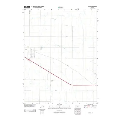
2009 Map of Quinter
USGS Topo · Published 2009About this map
Quinter and Collyer anchor this Gove County landscape, situated along a transportation corridor defined by Interstate 70 and the traditional path of Old Hwy 40. The map reveals a highly structured grid of county roads, such as Gove AA Rd and Gove 80, which serve the agricultural expanses between the drainage systems of Plum Creek in the north and Big Creek to the south. For those exploring family roots or local heritage, the map identifies key community sites including the Quinter Cemetery and the Old Order German Baptist Cemetery. The presence of the Quinter Air Strip and local landmarks like Castle Rock Rd illustrate the intersection of modern infrastructure and the geographic waypoints that define this part of the High Plains. The drainage of Coyote Creek near Collyer further highlights the subtle topographies that shaped early settlement patterns in the region.
Find a feature on this map
27 named features on this map. Tap any name to fly to it.
Don’t see what you’re looking for? This feature index may not catch every label — zoom into the map to look around manually.
Map Details
Editions of this 2009 Quinter Map
This is the sole edition of this map. No revisions or reprints were ever made.
Other maps of this area

1954 · Goodland
USGS Topo · 1:250,000

1955 · Scott City
USGS Topo · 1:250,000

1956 · Goodland
USGS Topo · 1:250,000

1957 · Goodland
USGS Topo · 1:250,000

1958 · Scott City
USGS Topo · 1:250,000

1972 · Gove NE
USGS Topo · 1:24,000

1972 · Castle Rock NW
USGS Topo · 1:24,000
1972 · Castle Rock NE
USGS Topo · 1:24,000

1979 · Park
USGS Topo · 1:24,000

1979 · Midway Draw East
USGS Topo · 1:24,000