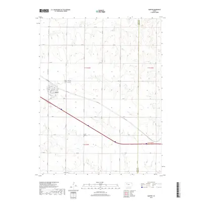
2018 Map of Quinter
USGS Topo · Published 2018About this map
Quinter serves as the primary hub of this High Plains landscape, situated along the path of Old Hwy 40 and Interstate 70. The town's grid is clearly defined by local streets such as Garfield St and Hackberry Dr, while the surrounding section lines illustrate a deep-rooted agricultural structure. Significant for genealogical research, the map identifies the Baker Township Cem north of town and the Old Order German Baptist Cem further south, suggesting a history of religious settlement in this part of Gove County. The terrain is marked by the drainages of Big Cr, Plum Cr, and Coyote Cr, which break the level plains. To the south, Jamison Field indicates localized aviation or agricultural activity amidst a network of rural roads like Co Rd 74 and Castle Rock Rd.
Find a feature on this map
50 named features on this map. Tap any name to fly to it.
Don’t see what you’re looking for? This feature index may not catch every label — zoom into the map to look around manually.
Map Details
Editions of this 2018 Quinter Map
This is the sole edition of this map. No revisions or reprints were ever made.
Other maps of this area

1954 · Goodland
USGS Topo · 1:250,000

1955 · Scott City
USGS Topo · 1:250,000

1956 · Goodland
USGS Topo · 1:250,000

1957 · Goodland
USGS Topo · 1:250,000

1958 · Scott City
USGS Topo · 1:250,000

1972 · Gove NE
USGS Topo · 1:24,000

1972 · Castle Rock NW
USGS Topo · 1:24,000
1972 · Castle Rock NE
USGS Topo · 1:24,000

1979 · Park
USGS Topo · 1:24,000

1979 · Midway Draw East
USGS Topo · 1:24,000