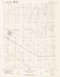
1979 Map of Quinter
USGS Topo · Published 1979About this map
The town of Quinter serves as the focal point of this western Kansas landscape in the late 1970s, situated at the border of Gove and Trego counties. This agricultural and transportation hub is defined by the east-west corridor of the Union Pacific railroad and the modern path of Interstate 70. Outside the structured grid of the town, the land is marked by local industry and community landmarks, including several Gravel Pits and Caliche Pits. To the south, the Old Order Ch stands as a significant cultural marker, while the drainages of Plum Creek and Big Creek carve through the high plains topography. The map detail extends to local amenities like the Golf Course and a small Landing Strip, providing a clear view of the mid-century infrastructure and land use patterns that sustained this rural prairie community.
Find a feature on this map
22 named features on this map. Tap any name to fly to it.
Don’t see what you’re looking for? This feature index may not catch every label — zoom into the map to look around manually.
Map Details
Editions of this 1979 Quinter Map
This is the sole edition of this map. No revisions or reprints were ever made.
Other maps of this area

1954 · Goodland
USGS Topo · 1:250,000

1955 · Scott City
USGS Topo · 1:250,000

1956 · Goodland
USGS Topo · 1:250,000

1957 · Goodland
USGS Topo · 1:250,000

1958 · Scott City
USGS Topo · 1:250,000

1972 · Gove NE
USGS Topo · 1:24,000

1972 · Castle Rock NW
USGS Topo · 1:24,000
1972 · Castle Rock NE
USGS Topo · 1:24,000

1979 · Park
USGS Topo · 1:24,000

1979 · Midway Draw East
USGS Topo · 1:24,000