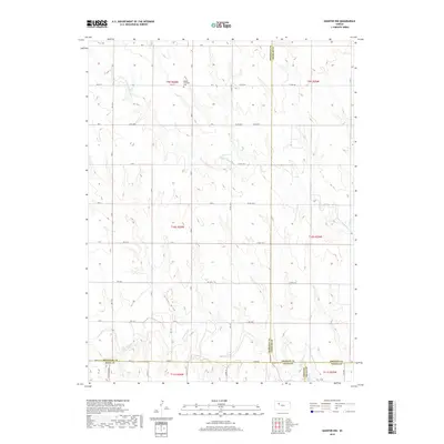
2018 Map of Quinter NW
USGS Topo · Published 2018About this map
Bethel Christian Cem stands as a primary landmark in the high plains of northwest Kansas, situated near the intersection of Co Rd 90 S and Co Rd 140 E. This landscape is defined by the drainage systems of the Saline River and its northern tributary, the N Fork Saline River, which cut through the terrain alongside Turner Draw. The map documents a strictly organized grid of rural roads, such as Castle Rock Rd and Co Rd 74, that mark the boundaries of Graham, Gove, Trego, and Sheridan counties. The area maintains its agricultural character, with long stretches of section-line roads providing access to the open country south of the N Fork Saline River and east toward Plum Cr.
Find a feature on this map
39 named features on this map. Tap any name to fly to it.
Don’t see what you’re looking for? This feature index may not catch every label — zoom into the map to look around manually.
Map Details
Editions of this 2018 Quinter NW Map
This is the sole edition of this map. No revisions or reprints were ever made.
Other maps of this area

1954 · Goodland
USGS Topo · 1:250,000

1956 · Goodland
USGS Topo · 1:250,000

1957 · Goodland
USGS Topo · 1:250,000

1979 · Park
USGS Topo · 1:24,000

1979 · Midway Draw East
USGS Topo · 1:24,000

1979 · Morland
USGS Topo · 1:24,000

1979 · Tasco
USGS Topo · 1:24,000

1979 · St Peter
USGS Topo · 1:24,000

1979 · Studley
USGS Topo · 1:24,000
1979 · Collyer
USGS Topo · 1:24,000