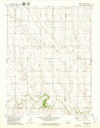
1979 Map of Quinter NW
USGS Topo · Published 1979About this map
The Sheridan State Game Management Area anchors the southern portion of this landscape, where the Saline River and its tributaries carve a complex drainage system through the High Plains. This late 1970s survey captures the region's resource-based economy, marked by numerous Oil Wells and a sprawling Oil field in the central townships of East Saline and Bryant. The presence of the Bethel Cem in the north and the distinct topographical feature of Turner Draw indicate the historical footprint of rural settlement and natural landmarks used for navigation. Resource extraction is further evidenced by several Sandpit sites and a Quarry located near the Gove and Trego County line. The confluence of the North Fork Saline River and the main stem provides a focal point for understanding the local hydrology before it continues eastward.
Find a feature on this map
22 named features on this map. Tap any name to fly to it.
Don’t see what you’re looking for? This feature index may not catch every label — zoom into the map to look around manually.
Map Details
Editions of this 1979 Quinter NW Map
This is the sole edition of this map. No revisions or reprints were ever made.
Other maps of this area

1954 · Goodland
USGS Topo · 1:250,000

1956 · Goodland
USGS Topo · 1:250,000

1957 · Goodland
USGS Topo · 1:250,000

1979 · Park
USGS Topo · 1:24,000

1979 · Midway Draw East
USGS Topo · 1:24,000

1979 · Morland
USGS Topo · 1:24,000

1979 · Tasco
USGS Topo · 1:24,000

1979 · St Peter
USGS Topo · 1:24,000

1979 · Studley
USGS Topo · 1:24,000
1979 · Collyer
USGS Topo · 1:24,000