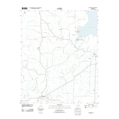
2011 Map of Quitman
USGS Topo · Published 2011About this map
Quitman sits at the southern edge of this landscape, where the road network transitions from the grid of the valley floor toward the elevation of the Boston Mountains. To the northeast, the sprawling waters of Greers Ferry Lake dominate the terrain, creating a jagged shoreline at Goff Point and filling inlets like Sweet Suck Hollow. This 2011 survey documents a mix of agricultural lowlands and rising hills, with prominent landmarks such as Pryor Mountain and Bettis Mountain overlooking the drainage of Cadron Creek. Local history is anchored by rural hubs like Pearson and Crossroads, while the Palestine Cemetery and Aldridge Cemetery provide valuable points of reference for genealogists. The map details the intricate hydrography of the region, from the winding North Fork Cadron Creek to smaller tributaries like Piney Creek and Yellow Bank Creek, reflecting the natural water systems that shaped the settlement of Cleburne County.
Find a feature on this map
88 named features on this map. Tap any name to fly to it.
Don’t see what you’re looking for? This feature index may not catch every label — zoom into the map to look around manually.
Map Details
Editions of this 2011 Quitman Map
This is the sole edition of this map. No revisions or reprints were ever made.
Other maps of this area

1892 · Mountain View
USGS Topo · 1:125,000

1894 · Mountain View
USGS Topo · 1:125,000

1956 · Russellville
USGS Topo · 1:250,000

1961 · Bee Branch
USGS Topo · 1:62,500

1961 · Morganton
USGS Topo · 1:24,000

1961 · Guy
USGS Topo · 1:24,000

1963 · Rose Bud
USGS Topo · 1:24,000

1963 · Quitman
USGS Topo · 1:24,000
1963 · Barney
USGS Topo · 1:24,000
1963 · Heber Springs
USGS Topo · 1:24,000