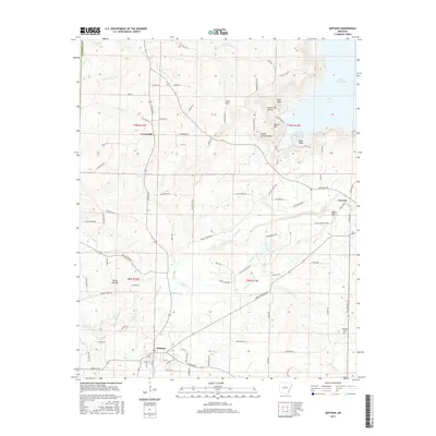
2017 Map of Quitman
USGS Topo · Published 2017About this map
The town of Quitman anchors the southern portion of this Cleburne County region, where the landscape transitions from established agricultural lands to the prominent ridges of Bettis Mtn and White Oak Mtn. The northern edge is dominated by the sprawling reaches of Greers Ferry Lake, including Goff Cove and Bean Point. This 2017 survey reveals a complex network of waterways, with Cadron Cr and its many tributaries like Beaver Cr and Yellow Bank Cr carving through the terrain. Smaller settlements such as Pearson and Crossroads serve as local hubs, connected by a dense web of rural routes like Quitman Rd and Bettis Mountain Rd. For the local historian, the map preserves the location of the Aldridge Cem and several distinctive hollows, including Sweet Suck Hollow and Sulphur Springs Hollow, which point to the area's older geographic nomenclature.
Find a feature on this map
110 named features on this map. Tap any name to fly to it.
Don’t see what you’re looking for? This feature index may not catch every label — zoom into the map to look around manually.
Map Details
Editions of this 2017 Quitman Map
This is the sole edition of this map. No revisions or reprints were ever made.
Other maps of this area

1892 · Mountain View
USGS Topo · 1:125,000

1894 · Mountain View
USGS Topo · 1:125,000

1956 · Russellville
USGS Topo · 1:250,000

1961 · Bee Branch
USGS Topo · 1:62,500

1961 · Morganton
USGS Topo · 1:24,000

1961 · Guy
USGS Topo · 1:24,000

1963 · Rose Bud
USGS Topo · 1:24,000

1963 · Quitman
USGS Topo · 1:24,000
1963 · Barney
USGS Topo · 1:24,000
1963 · Heber Springs
USGS Topo · 1:24,000