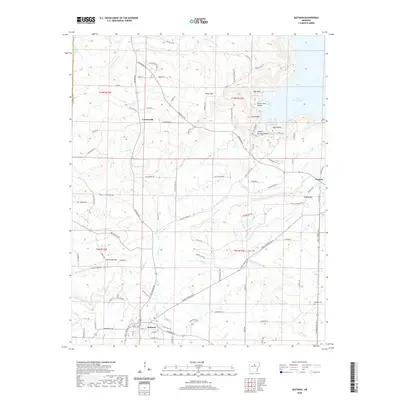
2020 Map of Quitman
USGS Topo · Published 2020About this map
Quitman serves as the primary hub in this corner of Cleburne County, where the southern foothills of the Ozarks meet the upper drainage of the Cadron Creek system. The landscape is defined by its numerous named peaks and hollows, including Pryor Mtn, White Oak Mtn, and the curiously named Sweet Suck Hollow. In the northeast, the waters of Greers Ferry Lake reach into the map area at Goff Cove, illustrating how modern reservoirs have reshaped the historical topography of the region. Local travel and commerce rely on a network of routes such as Quitman Rd and Heber Springs Rd W, connecting smaller settlements like Crossroads and Pearson. Genealogists will find interest in the Aldridge Cem located in the southeast, while the intricate system of branches and creeks, such as Adler Br and Mill Cr, highlights the importance of water for the area's rural development.
Find a feature on this map
112 named features on this map. Tap any name to fly to it.
Don’t see what you’re looking for? This feature index may not catch every label — zoom into the map to look around manually.
Map Details
Editions of this 2020 Quitman Map
This is the sole edition of this map. No revisions or reprints were ever made.
Other maps of this area

1892 · Mountain View
USGS Topo · 1:125,000

1894 · Mountain View
USGS Topo · 1:125,000

1956 · Russellville
USGS Topo · 1:250,000

1961 · Bee Branch
USGS Topo · 1:62,500

1961 · Morganton
USGS Topo · 1:24,000

1961 · Guy
USGS Topo · 1:24,000

1963 · Rose Bud
USGS Topo · 1:24,000

1963 · Quitman
USGS Topo · 1:24,000
1963 · Barney
USGS Topo · 1:24,000
1963 · Heber Springs
USGS Topo · 1:24,000