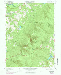
1973 Map of Rachelwood
USGS Topo · Published 1984About this map
Laurel Hill dominates the landscape of this 1973 survey, a prominent ridge where the borders of Westmoreland, Cambria, and Somerset Counties converge. The rugged topography is etched by numerous watercourses, including Tubmill Creek and Shannon Run, which descend toward the Conemaugh River in the northwest. In the valleys, evidence of early industrial and communal life remains, from the historical Baldwin Furnace on Baldwin Run to the Church in the Wilderness near Ross Mountain Park.
Find a feature on this map
49 named features on this map. Tap any name to fly to it.
Don’t see what you’re looking for? This feature index may not catch every label — zoom into the map to look around manually.
Map Details
Editions of this 1973 Rachelwood Map
This is the sole edition of this map. No revisions or reprints were ever made.
Other maps of this area

1904 · Johnstown
USGS Topo · 1:62,500

1907 · Johnstown
USGS Topo · 1:62,500

1913 · Somerset
USGS Topo · 1:62,500

1914 · Windber
USGS Topo · 1:62,500

1915 · Somerset
USGS Topo · 1:62,500

1916 · Windber
USGS Topo · 1:62,500

1920 · New Florence
USGS Topo · 1:62,500

1921 · New Florence
USGS Topo · 1:48,000

1922 · New Florence
USGS Topo · 1:62,500

1944 · Somerset
USGS Topo · 1:62,500
Featured Places
- Jenner Township, PA
- Fairfield Township, PA
- Ligonier Township, PA
- Conemaugh Township, PA
- Lower Yoder Township, PA