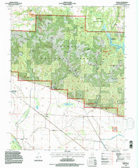
1994 Map of Raddle
USGS Topo · Published 1996About this map
The Murphysboro Ranger District of the Shawnee National Forest dominates this portion of Jackson County, where the rugged terrain of the Illinois Ozarks meets the Mississippi River floodplain. Small settlements like Raddle and Glenn sit on the level lands below the bluffs, while the upland interior is defined by a dense network of hollows, including Matusky Hollow and Talbott Hollow. The landscape preserves numerous family landmarks and cultural sites, such as the McCormick Cemetery and a noted Indian Mound near the base of the hills. Modern recreation and infrastructure are integrated into the timberland, evidenced by the Johnson Creek Recreation Area and the Turkey Track Rock Roadside Park Rest Area. The southern edge of the map is marked by the prominent rising of Fountain Bluff near Worthen Bayou, a distinctive topographical feature isolated from the main ridge system.
Find a feature on this map
41 named features on this map. Tap any name to fly to it.
Don’t see what you’re looking for? This feature index may not catch every label — zoom into the map to look around manually.
Map Details
Editions of this 1994 Raddle Map
2 editions found
Other maps of this area

1910 · Murphysboro
USGS Topo · 1:62,500

1916 · Campbell Hill
USGS Topo · 1:62,500

1918 · Altenburg
USGS Topo · 1:62,500

1918 · Campbell Hill
USGS Topo · 1:62,500

1924 · Alto Pass
USGS Topo · 1:62,500

1925 · Altenburg
USGS Topo · 1:62,500

1938 · Murphysboro
USGS Topo · 1:62,500

1947 · Alto Pass
USGS Topo · 1:62,500

1947 · Crosstown
USGS Topo · 1:24,000

1947 · Gorham
USGS Topo · 1:24,000