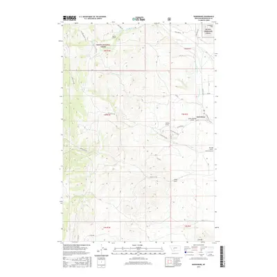
2017 Map of Radersburg
USGS Topo · Published 2017About this map
Radersburg occupies a small valley floor on the eastern edge of this 2017 survey, where residential streets like Johnson St and Mill Rd meet the surrounding ranchland of Broadwater County. The terrain to the west rises sharply into the Helena National Forest, a landscape defined by deeply incised drainages including Keating Gulch and Uncle Johnnys Gulch. This western sector is dotted with natural water sources such as Piedmont Spring and White Rock Spring, essential landmarks for the local cattle and mining industries that have historically shaped this region. To the northeast, the Limestone Hills overlook an intricate network of irrigation systems, most notably the Swede-Hollings Ditch and Dowdy Ditch, which redirect the waters of Crow Cr toward the lower fields. The map also identifies the NG Mta military training area and prominent peaks like Lone Mtn, providing a precise record of contemporary land use and topography.
Find a feature on this map
36 named features on this map. Tap any name to fly to it.
Don’t see what you’re looking for? This feature index may not catch every label — zoom into the map to look around manually.
Map Details
Editions of this 2017 Radersburg Map
This is the sole edition of this map. No revisions or reprints were ever made.
Other maps of this area

1886 · Fort Logan
USGS Topo · 1:250,000

1948 · White Sulphur Springs
USGS Topo · 1:250,000

1949 · Radersburg
USGS Topo · 1:62,500

1950 · Devils Fence
USGS Topo · 1:62,500

1950 · Townsend
USGS Topo · 1:62,500

1950 · Clancy
USGS Topo · 1:62,500

1958 · White Sulphur Springs
USGS Topo · 1:250,000

1961 · White Sulphur Springs
USGS Topo · 1:250,000

1965 · White Sulphur Springs
USGS Topo · 1:250,000

1976 · Townsend
USGS Topo · 1:100,000