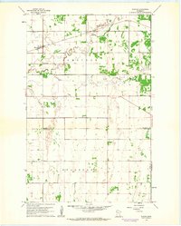
1961 Map of Radium
USGS Topo · Published 1963About this map
Radium serves as the primary settlement hub in this northwestern Minnesota landscape, positioned where the Soo Line railroad cuts across the prairie. The map captures a moment in the early 1960s when the rural social fabric was anchored by the Immanuel Ch and Immanuel Cem in the north and a Townhall farther south. The terrain is defined by the winding course of the Snake River and its South Branch Snake River, which meander through the townships of Comstock and Helgeland. This survey illustrates the precise section lines and field boundaries characteristic of the Red River Valley's agricultural development, punctuated only by occasional industrial features like a Gravel Pit. The convergence of Marshall Co and Polk Co lines, along with the Polk and Pennington Co borders, highlights the area's administrative complexity.
Find a feature on this map
13 named features on this map. Tap any name to fly to it.
Don’t see what you’re looking for? This feature index may not catch every label — zoom into the map to look around manually.
Map Details
Editions of this 1961 Radium Map
2 editions found
Other maps of this area

1918 · Angus
USGS Topo · 1:62,500

1918 · Viking
USGS Topo · 1:62,500

1952 · Thief River Falls
USGS Topo · 1:250,000

1956 · Thief River Falls
USGS Topo · 1:250,000

1956 · Florian
USGS Topo · 1:62,500

1957 · Thief River Falls
USGS Topo · 1:250,000

1957 · Newfolden
USGS Topo · 1:62,500

1959 · Viking
USGS Topo · 1:24,000
1959 · Viking SW
USGS Topo · 1:24,000

1961 · Radium
USGS Topo · 1:24,000