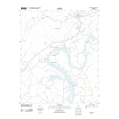
2011 Map of Ragland
USGS Topo · Published 2011About this map
Ragland serves as the primary population center on this portion of the Coosa River, situated just north of the expansive Logan Martin Lake. The landscape is defined by the river’s winding path, forming prominent geographical features like Embry Bend and Kirkseys Bend. In the northern section, Henderson Mountain and Mitchell Mountain rise above the valley, while the river's flow is regulated at National Dam near National Lake. The settlement patterns here reflect a mix of established community centers and newer lakeside developments like Sherwood Shores. Local history is preserved in several burial grounds, including the Old Mitchell Cemetery and Box Cemetery, which are scattered throughout the hills. The presence of Old Mining Rd suggests the area's industrial past, likely linked to the quarries and mineral resources found near the ridge lines.
Find a feature on this map
98 named features on this map. Tap any name to fly to it.
Don’t see what you’re looking for? This feature index may not catch every label — zoom into the map to look around manually.
Map Details
Editions of this 2011 Ragland Map
This is the sole edition of this map. No revisions or reprints were ever made.
Other maps of this area

1889 · Springville
USGS Topo · 1:125,000

1892 · Springville
USGS Topo · 1:125,000

1947 · Cox Gap
USGS Topo · 1:24,000

1947 · Eastaboga
USGS Topo · 1:24,000

1947 · Ragland
USGS Topo · 1:62,500

1947 · Ragland
USGS Topo · 1:24,000

1947 · Riverside
USGS Topo · 1:24,000

1947 · Francis Mill
USGS Topo · 1:24,000

1947 · Steele
USGS Topo · 1:62,500
1949 · Ohatchee
USGS Topo · 1:24,000