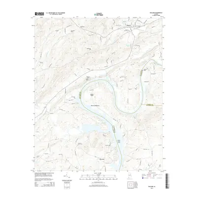
2014 Map of Ragland
USGS Topo · Published 2014About this map
The Coosa River defines the geography of this Alabama landscape, winding through complex terrain where St. Clair, Calhoun, and Talladega Counties meet. The river's path is marked by dramatic bends, notably Embry Bend and Kirkseys Bend, and the historic Broken Arrow Shoals. To the south, the river widens significantly into Logan Martin Lake, bordering the community of Sherwood Shores. Transport and industry are centered in the north at Ragland, where the CSX Transportation railroad intersects the town's grid near Trout Cr.
Find a feature on this map
63 named features on this map. Tap any name to fly to it.
Don’t see what you’re looking for? This feature index may not catch every label — zoom into the map to look around manually.
Map Details
Editions of this 2014 Ragland Map
This is the sole edition of this map. No revisions or reprints were ever made.
Other maps of this area

1889 · Springville
USGS Topo · 1:125,000

1892 · Springville
USGS Topo · 1:125,000

1947 · Cox Gap
USGS Topo · 1:24,000

1947 · Eastaboga
USGS Topo · 1:24,000

1947 · Ragland
USGS Topo · 1:62,500

1947 · Ragland
USGS Topo · 1:24,000

1947 · Riverside
USGS Topo · 1:24,000

1947 · Francis Mill
USGS Topo · 1:24,000

1947 · Steele
USGS Topo · 1:62,500
1949 · Ohatchee
USGS Topo · 1:24,000